Archive

Monthly Archives: July 2017

US Map 1836_DavidRumsey

This 1836 map by James Webster comes from the David Rumsey Historical Map Collection.

By Thomas Richards, Jr.

This past June the Huntington Library generously provided me a fellowship to research its vast manuscript holdings in the history of the American West. The research was meant to provide additional sources for my book manuscript, tentatively titled The North America that Almost Was: Breakaway Republics and Contested Sovereignty in the Era of Manifest Destiny, which is based upon a dissertation I defended at Temple University in the fall of 2016.

My study examines the motivations and subsequent actions of Americans who left U.S. borders between 1836 and 1846, for places as diverse as the Republic of Texas, Upper Canada, Indian Territory, Oregon Country, and Mexican California. Historians have often defined these American migrants as harbingers of the United States’ “Manifest Destiny,” who longed to expand U.S. borders. However, a closer reading of their letters and diaries at the time reveals a much more complicated story, one in which most migrants left U.S. borders because the United States no longer facilitated their economic and social ambitions. Thus, once beyond these borders, migrants cared little whether the United States would expand in the near future, but instead sought to assert local sovereignty that would further their own goals. Indeed, for several years in the late 1830s and early 1840s, migrants (and many other Americans) imagined that the United States would never expand, but rather North America would be composed of several Anglo-American republics. My study concludes with a reinterpretation of the politics surrounding the Mexican War and the Oregon Treaty. I argue that one overlooked reason for Polk’s aggression was because he reached a similar conclusion as many migrants; for him, however, any independent Anglo-American republic would be a distinct threat to U.S. expansion, and thus the independent political actions of Americans beyond U.S. borders needed to be promptly curbed.

While at the Huntington, I have been primarily examining the library’s rich sources on Mexican California, including both the papers of Californios and Americans who already resided in the territory, as well as the diaries and letters of American overlanders traveling to the region. These include prominent collections like the Abel Stearns Papers, and also lesser known holdings such as “Affidavits of Americans in Mexico, 1840,” in which Americans captured during the infamous Graham Affair provided statements of what their lives were like in California prior to their arrests. In addition, I have also explored collections on Oregon Country, particularly the Elkanah Walker papers, as well the Huntington’s substantial holdings of overland trail diaries and travelogues detailing the journey to Oregon. The Huntington’s Mormon File has likewise been immensely helpful to my research, especially the Mormon Battalion diaries in the collection. Remarkably, I have even found several useful items in areas that the Huntington is not known for – on Indian Territory in the 1830s (most are located in the American Indian File) and even Upper Canada (found in disperse items like the Gilbert Belnap Autobiography and the Edmund Kirby Papers).

In the coming months I will start a postdoctoral fellowship at Clements Center for Southwest Studies at SMU, where I will integrate these sources into my manuscript. I thank the Huntington for its generosity, its librarians and archivists for their kindness and immense help with my research, and its other fellows for the many interesting discussions over lunch and coffee.


After receiving his PhD from Temple University, Thomas Richards, Jr. will start his postdoctoral fellowship at the William P. Clements Center for Southwest Studies at Southern Methodist University in the Fall.

West Work is ICW’s blog series highlighting Western History scholars’ findings based on their research in local archives.


Screen Shot 2017-07-24 at 12.45.09 PM.png

Studio portrait of Aldous Leonard Huxley (circa 1942) from the Edwin Hubble Papers archived at the Huntington Library.

By Peter Richardson

On this day in 1894, Aldous Leonard Huxley was born into a prominent family of writers, scientists, and physicians. He studied literature at Oxford and established himself as a successful novelist, poet, and journalist. A member of the Bloomsbury Set, he also befriended D.H. Lawrence and later edited his letters.

Huxley’s fifth novel, the dystopian Brave New World, appeared in 1932. It was both a jab at the earlier utopian works of H.G. Wells and a complex response to the fast-paced, unreflective, and technology-obsessed mass society that Huxley saw around him. Brave New World brought him even more notoriety, but his outspoken pacifism alienated him from his British peers, and he decided to move to the United States.

In 1937, Huxley and his family arrived in Hollywood. Like many established writers, he considered the film industry a reliable source of cash. As David King Dunaway documents in Huxley in Hollywood (1989), he and his wife Maria led a busy social life that included Charlie Chaplin and Paulette Goddard, Grace and Edwin Hubble, Gerald Heard and Christopher Isherwood, Igor Stravinsky, J. Krishnamurti, Jake Zeitlin, Anita Loos, and Greta Garbo. Huxley’s film credits included Pride and Prejudice (1940), but he also worked on Madame Curie (1943) and Jane Eyre (1944). His film career collapsed in 1952 after a cover story in Counterattack, a right-wing magazine, described him as a Communist dupe.

Intrigued by the links amongst drugs, consciousness, and art, Huxley persuaded British psychiatrist Humphry Osmond to dose him with mescaline in 1953. The Doors of Perception (1954) recounted Huxley’s experience on that day. Reviewers panned the book, whose title echoed a passage from William Blake’s The Marriage of Heaven and Hell, but Huxley was unfazed. He continued to trip several times a year for the rest of his life, and his book spread the word about the virtues of psychedelic drugs.

After Maria Huxley died in 1955, Aldous invited therapist Laura Archera to his home to guide a mescaline experience. Their relationship flourished—in part over their shared interest in hypnotism, psychedelics, and spirituality—and they married in 1956. Like Maria, Laura had romantic relationships with women, and the newly married couple bought a home in the Hollywood Hills close to Virginia Pfeiffer, her longtime friend.

In 1960, Huxley was diagnosed with cancer, but he managed to finish Island the following year. Frank Kermode called it “one of the worst novels ever written,” but along with Robert Heinlein’s Stranger in a Strange Land and Kurt Vonnegut’s Cat’s Cradle, Huxley’s fiction chimed well with the rebellious spirit of that decade, especially on college campuses.

In 1962, Huxley accepted a teaching position at the University of California, Berkeley, but his health declined quickly the following year. He died in Los Angeles the same day John F. Kennedy was assassinated. His former daughter-in-law noted, “As he got older, I think he became more and more available … By the time he died, he was very young.”


Peter Richardson coordinates the American Studies and California Studies programs at San Francisco State University.


JacksonWyoming

Postcard of Jackson, Wyoming (circa 1924) courtesy of the University of Wyoming, American Heritage Center.

By Bill Deverell


My mother always said, “it’s good to go away, and it’s good to come home.” Our last few days in Wyoming were magnificent. John and I met up with our friends Sage and Sassy, from the ranch, on Thursday in Jackson. That was fun, just hanging out. Sage is, well, a sage. She knows Wyoming, she knows the fissures of class and tourism and tectonic economic change, and she has a way with words. Sassy — she of the new purple hair — is fun and ever lively, a great Wyoming pal for my city-boy son. The town is more crowded this summer than I’ve ever seen it. Lots of factors to explain that. Cheap gas. Stock market up. Eclipse coming. National Parks inundated. European and Asian tourism looks (and sounds) to be up. The little town struggles with it all. Housing is a mess: anyone not really wealthy struggles to find places to live within reasonable distance. Many workers in town live well south of Jackson or up and over Teton Pass in Idaho. I grew up in Colorado, and I recognize the “Aspen Syndrome” or the “Vail Paradox.” Tourists come and keep coming. Fine dining and shopping pops up to cater to them 12 months a year. But where do the workers who stock those shelves or cook those lamb chops or make those lattes live? And how much must you pay them to give them even a faint shot at reasonable housing? This isn’t a new set of challenges to Jackson, to be sure, but the pressure and the scale of the challenges only seems to be more pressing each time I go there.

On our last day in Wyoming, John went off to camp and the high-ropes course at Teton Science School. After my last day at the gym (if you go to Jackson, if you like gyms and gym rats, and if you don’t mind getting intelligently beat on in a training-session hour, go to Wright Training and tell Crystal Wright I sent you), I had the distinct pleasure of spending mid-day with folks from Teton Science School as they showed me the Murie Center, inside Grand Teton National Park. I knew of it, but I had never been there. What a revelation. The Center, which is a former dude ranch from the early 20th century, later became the home of two pairs of husband and wife conservationists: Olaus Murie and his wife Margaret (Mardy) Murie, and Olaus’s half-brother Adolph Murie and his wife, Louise, who was Mardy’s half-sister, if you can believe it.

Mardy_Olaus_Murie

Olaus and Mardy Murie. Photo courtesy of the Murie Center.

These folks belong in the same hushed sentences, and in similar legacy lore, as Henry David Thoreau, John Muir, David Brower, Wallace Stegner, Ansel Adams, and lots of Udalls. They are heroes and heroines of the latter-day conservationist movement in America. Because of Olaus and Mardy, the Wilderness Society was headquartered here in the years after World War II, and it was here, in these cabins and on the Muries’ very front porch, that the Wilderness Act (1964) was imagined and conceived. That Act made law and landscapes out of a simple, profound declaration: that there exists, and ought to always exist, places “where the earth and its community of life are untrammeled by man, where man himself is a visitor who does not remain.”

The Muries, their ranch, their ideas, and their courage made that happen. In honoring their legacy, the Murie Ranch was designated a National Historic Landmark in 2006. More recently, Teton Science Schools has forged an innovative relationship with the Murie Center to keep those intellectual flames burning. As TSS states, “The Murie Center is dedicated to bringing people together to inspire action that protects nature – an opportunity and obligation passed on through the legacy of the Muries. The Murie Center continues to play an important role in ensuring the betterment of the future for all life, because when nature thrives, people thrive.”

My few hours there were inspiring beyond measure. Plenty of “history happened here” feelings to keep an historian happy. But — more than that — a spiritual feeling about the place, too. Commitment to work, commitment to nature, commitment to a beloved partner (what a love affair Olaus and Mardy had!), commitment to leaving this world just bit better off — here’s a place to breathe all that in and be renewed by it. My new friends from TSS and I are thinking about what we might do together there at the Murie Center. How I would love to bring students there — graduate students doing western history doctoral work, undergraduates, or even a freshman seminar. Stay tuned, I think we’ll find a way, and I want especially to thank Josh from TSS for his warmth and hospitality in making my visit happen with such decency and kindness.

John and I soon departed. Off to Salt Lake by way of up and over Teton Pass (glorious), on through Idaho (same), and to downtown Salt Lake to stay where we always stay. Dinner at Red Rock, and the great Farmer’s Market in Pioneer Park the next morning before heading out again. On to St. George, arriving in plenty of time for dinner (again!) at Painted Pony, which is uniformly, always superb. Up this morning, point the car south on I-15, and, by early afternoon, home in Pasadena.

A glorious trip.

IMG_0451

Just thinking in Wyoming. Photo by Bill Deverell.

Los Angeles City Water Company

The Los Angeles City Water Company headquarters sits just above the Plaza in this photo (circa 1890s). Photo courtesy of the Historical Photo Collection of the Department of Water and Power, City of Los Angeles.

By Tom Sitton


Here we are on July 20, the 149th anniversary of an important date in the history of supplying many of us with the necessary wet resource that kept Los Angeles growing. For on that date in 1868 the Los Angeles City Water Company received its thirty-year lease to provide the city’s residents with nature’s gift by operating its water system.

That event followed a number of years in the mid-1800s, when early water providers faced many difficulties in building crude infrastructure to distribute water from the Los Angeles River and other sources to thirsty Angelenos. By 1868 city officials were desperate for help, and three entrepreneurs offered to solve their problem. Although there were many critics of the final lease agreement, the city leaders saw no other solution to their dilemma and a majority of the common council agreed to a thirty year lease for distribution of the city’s water.

Conflicts between the city and the company began soon after the firm took over, as its directors fought to reduce their annual rent payments to the city, reneged on building promised infrastructure, and even challenged the city’s ownership of the water. While the company amassed generous profits from the business, residents complained of bad service, high rates, slimy water and low pressure. As the Los Angeles population boomed in spurts in the 1870s and 1880s, the protests became louder with the transformation of the area from primarily agricultural to commercial and residential.

By the time the lease period was ending in 1898, public outcry against a renewal of the lease had crystalized with a demand for the city to take over its water system. The lease became a major issue in the 1896 city election in which opposition candidates were successful. The new council members began negotiating, but the sales prices demanded by the company and the city were far apart and ended up in arbitration that still did not solve the problem. The council decided to build the city’s own infrastructure for distribution instead of purchasing the company’s system, which would leave the firm with pipes, pumps and such, but without water. Several lawsuits ensued and a compromise was finally worked out — the city took over the company’s property in 1902, almost four years after the lease had expired.

The transfer of ownership of the city’s water system from private entrepreneurs to the city was an example of the early reform sentiment in Los Angeles that would increase during the early Progressive era movement that was sweeping the nation at this time. The municipal ownership drive of urban reformers was a key ingredient in progressivism, particularly in owning natural resources and other necessities for residents. Los Angeles would soon have full control of its water supply and eventually its electrical, harbor, and airport services as it does today.

So Happy Anniversary, Los Angeles City Water Company, and thanks for your contribution to the early history of Los Angeles growth and its environmental and political history.


Tom Sitton is History Curator, Emeritus of the Natural History Museum of Los Angeles County. For more on the Los Angeles City Water Company see books by Ostrom, Fogelson, Hundley, Karhl, Mulholland, and Soifer.

IMG_0475

The Tetons as a summer storm rolls through. Photo by Bill Deverell.

By Bill Deverell

Up through Hoback Canyon and on to Jackson Hole. Sometimes the West challenges conventional ways of thinking about time and space in American history. A case in point is the landscape John and I drove through yesterday on our way to Jackson Hole. From outside Daniel, we drove through Bondurant, a crossroads town on either side of the state highway. A year ago, we had driven through here just as a lightning strike caused a fire in the National Forest. Within hours, the road to Jackson was closed, and the fire eventually grew to more than 30,000 acres. Firefighters fought it near buildings and campsites, and they allowed it to burn in unpopulated areas as part of the ecological management of the forest. It did not go out until precipitation knocked it down completely in September.

As we dropped into Hoback Canyon, we could see the burn; it looked like it had gone through yesterday, not a full year ago. Beetle kill of the pines makes them especially susceptible to fire, and this one of 2016 clearly was opportunistic in that way. Hoback Canyon, alongside the Hoback River, is one of the prettiest drives I know in the West. The Hoback is a tributary of the mighty Snake, and once we run into the Snake, I know we are getting close to Jackson.

The Hoback is named for John Hoback, a trapper and mountain man who wandered through this area more than 200 years ago. He was, like many a mountain man of his time, from Kentucky. In 1811, Hoback and two other mountain men guided a group of trappers headed to the mouth of the Columbia River through this landscape. The group headed to the Pacific Coast was the Astorians — men sent by John Jacob Astor to establish a fur-trapping and fur-trading entrepôt at the far end of the continent by way of Astor’s Pacific Fur Company. These men were one-half of a two-pronged scheme; the other group left for the Pacific Northwest coast by sea, carrying the material needed to build the operation. The overlanders were tasked with establishing fur trading and trapping operations in the Rockies and west from the Snake to the Columbia.

Hoback and his companions guided the Astorians (led by wilderness novice Wilson Price Hunt of Trenton, New Jersey) across this landscape we drove through yesterday, from the river now bearing Hoback’s name to its confluence with the Snake. The group went on up into Jackson Hole (the “hole” is the valley between the Teton and Gros Ventre ranges), climbed up and over the Tetons, and made it to a fort in Idaho. On the way back east in 1812, a remnant party of Astorians found South Pass in the Wind River mountains, a relatively easy crossing of the Continental Divide, thus marking the landscape for the Oregon Trail migrants who would come a generation later. We could probably say that was their greatest success; the fur trading empire Astor envisioned fell apart for any number of reasons: mismanagement, squabbling, poor relations with native peoples, the coming of the War of 1812. John Hoback left his mark, too, in this canyon and on this river. That carries his name forward, well beyond his own 1813 death by Indians near what is now Boise.

The time bending aspect of this story comes from just thinking about these continental ambitions way out here, so early in the history of the Republic. When Kentuckian John Hoback guided the Astorians through this landscape, another Kentuckian, Abraham Lincoln, was a two-year old toddler. James Madison was President of the United States, all fifteen of them. John Marshall was Chief Justice of the Supreme Court. The Battle of Tippecanoe took place that year. The nation was thirty-five years old.

We made Jackson by dinnertime. As dusk came, so, too, did a big thunderstorm and lightning display. We sat on the deck of the house, huddled under the eaves, and watched as the lightning lit up the sky and everything around us through the pounding, cold rain. My son starts camp tomorrow at the wonderful Teton Science School, where he’s been a summer student each of the last four summers. I’ll go to the Teton County Public Library — a special place in my heart — to get some work done. At night, rain or not, we’ll sit on the deck some more and just watch mountains.

By Bill Deverell

Screen Shot 2017-07-14 at 6.43.26 AM

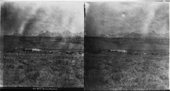
Very rare glass plate stereoscopic views c. 1859 taken by Albert Bierstadt, courtesy of Wyoming’s Museum of the Mountain Man.

Today I saw a landscape that blew my mind. This is not unusual out here; the rolling ranch lands of Sublette County, with the Teton and Wind River ranges perched on separate horizons, provide vistas of awe in every direction one looks. Up close, grasses and wildflowers, pronghorn antelope, deer, rabbits, smaller critters. We have a lone wolf and a mountain lion on prowl near the ranch, which has sent the dogs into fierce barking in the wee hours of each night. I haven’t seen them, and I don’t expect to. John and I have seen one wolf on our annual trip, a few years ago, atop a mountain pass: a big, black male with a limp running across the open terrain in the rain.

This landscape I saw today wasn’t on a hike, or from the ranch house, or from the car. It was in a museum, the Museum of the Mountain Man in Pinedale. This charming history museum is a winner: great artifacts of the fur trade, good displays of the lure of the beaver and its sumptuous pelt, indigenous artifacts and stories woven into the mountain man lore with appropriate complexity. Downstairs, tucked away in a case at the far end of an anteroom, were two blown up black and white photographs. One showed a line of wagon trains working across the face of a hill, the other showed encamped emigrants on a wide expanse of grassland, their cattle in the foreground, snowy mountains in the back.

Emigrant or overland wagon train imagery, at least before the Civil War, is rare – really rare. I don’t know if I’ve seen any at all. I looked at these blown up images and thought, at first, that these were either post-Civil War or, more likely, film stills from some early 20th century western.

Screen Shot 2017-07-14 at 6.43.41 AM

Very rare glass plate stereoscopic views c. 1859 taken by Albert Bierstadt, courtesy of Wyoming’s Museum of the Mountain Man.

Nope. These were 1859 glass plate stereographic images of overlanders cutting right through this part of Wyoming, no more than about twenty or thirty miles away. John and I had come through this landscape the other day, and I had noted a few historical markers touching upon the wagon trains, their campsites, even the continued presence of wagon ruts etched into the soil. But photographs? I’d never seen any this early before.

The story gets better. The photographer was Albert Bierstadt (1830-1902), the great landscape painter whose huge Romantic paintings of western scenes, skies, and indigenous inhabitants of the land excited American and European imaginations of sublime possibilities of experience and awe in the era of Manifest Destiny. We know Bierstadt as a painter, and as a painter of huge canvases fixed in gigantic frames. But a photographer? Maybe I knew that once, a long time ago, and I think I knew that he had a brother who was a photographer. Given the scarcity of any of Albert’s images, I guess I forgot or never knew in the first place that he took pictures, too.

The story gets even better. These images came to light by way of … eBay. Yep. And thanks to the sharp eye and historical sleuthing of Clint Gilchrist, now the museum’s executive director, they have come to reside here. Clint thinks that they are the earliest wagon train photographic images known, and I don’t doubt that he’s right.

Could the story get any better? Yes! Clint very kindly showed me the two glass plates, with their nearly identical positive images paired up side-by- side, two to a plate. Stereographic photography uses two images in which the photographic vantage is different only by a few degrees; these plates would have been used to print cardboard mounted images which, when put into a binocular viewer, would have created the illusion of three-dimensional depth. The viewer’s eyes and brain would overlap the images so that the picture would hover just in front of them, as if they were looking out a window at the scene itself. They were all the rage in the second half of the nineteenth century.

Clint even found the spot near the Big Sandy River where Bierstadt made the image of the cattle and encamped emigrants. He showed me on his computer how he merged the modern and 1859 pictures. The snow-capped mountains align perfectly, and Clint even filled the grassland with modern cows and their overland ancestors scattered here and there. It was awesome.

I want to thank Clint for a memorable visit to this museum and to the past. You really do learn something new every day, and thank goodness for it.


These two rare images of an emigrant wagon train, as seen at Wyoming’s Museum of the Mountain Man, can be found on the University of Wyoming’s web site.

IMG_0349

Outside Eden, Wyoming. Photo by Bill Deverell.

By Bill Deverell

In the paths of the overlanders. We left Rawlins yesterday morning headed for a ranch outside of Daniel, Wyoming. Our route took us right by the spot where Butch Cassidy and his gang allegedly blew up a rail car with a too-enthusiastic load of dynamite. Before long, we were in Rock Springs. This gritty railroad town in Sweetwater County (the fourth biggest city in sparsely populated Wyoming) shares an ignominious history with Los Angeles – both have notorious Chinese massacres in their past. In the fall of 1871 Los Angeles, a mixed mob of Caucasian and Latino men attacked the Chinese near the Plaza, shooting and hanging men and boys (and defiling the corpses post-mortem) in an orgy of racial enmity and fury. Fourteen years later, the massacre in Rock Springs looks depressingly familiar. White coal miners and railroad workers, infuriated that the Union Pacific hired Chinese workers over them (because it paid them less), rioted and a pitched battle took place. When it was all over, nearly thirty Chinese had been killed. I told my son about this place and what it sadly shared in common with our home in Southern California; he was puzzled as he thought about how this little railroad town in western Wyoming could possibly be mentioned in the same sentence with the big metropolis of our home on the west coast.

On through the spectacular treeless landscapes. Rivers – full to their banks by way of a spring run-off still flowing – cut through here and there, divine trout water. It’s nerdy to say it, but you can feel the past out here. Overlanders came through here – migrants from Joplin and St. Louis and elsewhere who wagon-trained it out here in the 1840s and 1850s, bound first for Oregon and then, in the flash of gold fever, increasingly made their way to California.

A wonderfully talented former graduate student of mine, Sarah Keyes (now on the faculty of the University of Nevada, Reno) wrote her thesis on these people. Who they were, what they did on the long months of their tough journey, how they interacted with the indigenous peoples, and, most tellingly, how they died out here in the big sky country of the West. Sarah’s contention, and I think she is right, is that we have cleaved this westering experience off from the rest of American history and culture in the period; we’ve made it into its own thing – the Overland Trail – without interrogating it for what it can tell us about everything else other than that long walk and ride west. What intrigues Sarah most are the rituals and meanings of death on the trail, and she’s on to something big. Think about it: the overland experience took in several hundred thousand people, vast numbers of them wrote about it as participants or afterwards, and many an emigrant died before getting to Oregon or California. Disease took them. They drowned (a lot of them drowned). They died from accidents. They shot themselves, deliberately or not. They killed one another. Just before the Civil War, this was the biggest mass experience with death in American history, and Sarah’s about to publish her book about all that. I recommend it highly.

IMG_0357

On a ranch in Wyoming. Photo by Bill Deverell.

We pushed on into Sublette County – named for one of the famed Sublette batch of five brothers (William, Milton, Andrew, Pinkney, and Solomon), trappers and mountain men of the early era all. Into Pinedale, the county seat and a great little town, with river and creek waterways cutting here and there through it. On to a spot marking the Green River Rendezvous, the fur trapper and trader “fair” (“bacchanal” may get a bit closer to the ambience) which took place each spring. Anne Hyde, a brilliant historian and dear friend, has written of these events (surely the most culturally and linguistically diverse gatherings of the era) in her magnificent book Empires, Nations, and Families: A New History of the North American West, 1800-1860.

Through Daniel, a spot-in-the-round with not much more than a store, a bar, and a post office (I expect to patronize all three), and then to our ranch destination. No trees, vast vistas, sand hills, the soul of a wide-open space. Ranch dogs – Rooney, named for the British soccer star Wayne Rooney, and Humungous, named for his own self, an Italian sheepdog of great heart and proportion. Oh – and Sassy, an aptly nicknamed ten-year old girl who lives here on the ranch, a boon companion to my boy for our visit over the next several days.

IMG_0329

Bill Deverell and his son stop for dinner at Buck’s Sports Grill in Rawlins, Wyoming.

By Bill Deverell

Rawlins, Wyoming. Drove up here yesterday from Colorado Springs, right alongside Front Range. These are the baby Rockies that, in their north/south alignment, help create landscapes of great beauty and attraction up against their eastern-facing flanks. The Front Range, I learned as a kid, is where all the people are and hardly any of the water, and that’s even more true today.

We took the back road, state highway 287, from Ft. Collins (home to CSU and a superb history department) on up to and across the Wyoming border. This is a glorious drive: rocky canyons of red soils, vistas of fifty and sixty miles, every now and then a one-room church with a little steeple sitting in vigil on the open range. French place and river names are flecked here and there, leftovers from the early 19th century when French trappers and traders came through. Best known in these parts is probably the Cache la Poudre River, so named in the 1820s when French trappers got caught in a snowstorm and buried some of their gunpowder on the river’s banks. We hit a big rainstorm at the border, just before Laramie. Because you can see so far out here, the rainstorm sat on the horizon in sheets and sheets — lightning shooting down in big bolts every few minutes — for a long time before we drove right into it.

We made Rawlins by dinnertime, getting a little further than I thought we would. That will make today’s drive to our fishing range destination, near Daniel, Wyoming, a snap. Rawlins is a tough place — the Wyoming State Penitentiary is here, along with its maximum-security inmates. A precursor facility, the Wyoming Frontier Prison, sits in the center of town. It is the 1901 re-do of an 1872 prison. Tours run regularly through the castle-like structure, which, as we drove by at dusk, looked nearly as ominous and imposing as it no doubt was in its heyday. Especially “incorrigible” prisoners were housed in the “dungeon house” portion of the penitentiary. Many an inmate was executed here, mostly hanged from gallows or killed by gas. The last woman inmate, who had murdered her father with a poison plum pie, arrived for a brief stay in 1909, before being transferred to another site. A quick glance at the website describing the history and tours (and urging visitors to “Come Hang With Us”) gives a little sense of the context of the prison’s early years. Train robbers were behind bars here, as were men on either side of the often-bloody range wars that pitted cattlemen against sheepmen. Rawlins is a fascinating place — those early days peek around the corners of its buildings and storefronts to this day, the U.P. railroad tracks run right through town, and this haunted hulk of a prison is still telling stories.

Dinner for us was at Buck’s in town (the menus are big!), a boisterous and friendly place with all kinds of Old West paraphernalia on the walls. I spy Butch Cassidy’s prison mug shot on the wall. Born in Utah 1866 as Robert Leroy Parker to Mormon emigres from England, Cassidy took the name of a ranch hand mentor and put together a notorious band of outlaws late in the century. There are pictures of some of his “Hole in the Wall” gang up as well. The “Hole in the Wall,” a secluded pass through a rocky mesa about 200 miles north of here, was a notorious outlaw hideout, ca. 1880-1910, and Cassidy apparently knew it well. I don’t see Etta Place up here, but I bet she’s somewhere. A Denver schoolteacher, Etta was the girlfriend of Harry Longabaugh, Cassidy’s sidekick, better known as the Sundance Kid. She went to South America with the outlaws in the early 20th century, when things got way too hot for them in Wyoming and the Great Basin. She supposedly returned to Denver to undergo an appendectomy, at which point she disappears into history’s mists. Cassidy and Longabaugh, as the great Paul Newman/Robert Redford film depicts so movingly and well, look to have been killed in a shootout with authorities in Bolivia, though Butch may have somehow avoided that fate, as many still claim.

Not far from Rawlins — we will drive right by it this morning — is the site of one of Butch Cassidy’s signature train robberies made famous in the film. Having stopped the train, Cassidy and his men then blew up the baggage car to smithereens with dynamite, prompting, in the film, Redford (as the Sundance Kid) to ask, “Do ya think you used enough dynamite there, Butch?”

GlenwoodSprings_DenverPublicLibrary

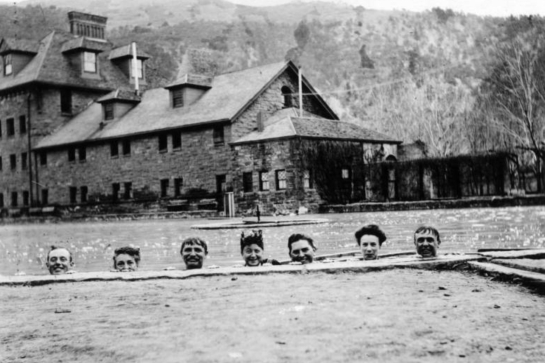
A photo of the Glenwood Springs Bath House (circa 1910) courtesy of the Denver Public Library.

By Bill Deverell

Day Four. Spent the night in Grand Junction, Green and Colorado River country. Hot and dry. Dinner at a pub in Grand Junction’s old downtown. A bit of Dublin broke out while we were there: an eight-piece band playing traditional Irish music. Gave the evening an added dose of cheerfulness.

Up and out pretty early, climbing towards the canyon country of the Colorado River near Glenwood Springs. A quick stop in Palisade, heart of the state’s peach-growing country to fill the car up with a box of peaches, sweet and tiny plums, peach salsa, peach and jalapeno jam, and some rhubarb jam. The plums went fast. Palisade is a beautiful little town, hard up against sheer canyon walls and mesas, drawing, I suspect, all its irrigation from the Colorado River. The peach grower I talked with said that the water rights for his orchard went back to the 1930s, and that his neighbor grower had rights that stretched back to the early 1900s. Irrigation canals cut from the river crisscross the landscape, and the valley that Palisade sits in looks like a plein air painter’s paradise.

Arrived later in the morning at Glenwood Springs, home to the famous hot springs and “the world’s largest hot springs swimming pool.” The town is tucked in the canyon and sits directly atop geothermal activity that bubbles and boils water from down below. Sulphur, rotten egg smells mingle with the gurgle of the springs. The springs at the Glenwood Hotel have been a tourist and health seeker attraction since the 1880s – people come from far and wide to sit in, and even drink, the warm water. The notorious gunman, gambler, and dentist, John “Doc” Holliday, died in this very hotel, tuberculosis (and hard living) having caught up with him at the young age of 36. His was an extreme case – he was an unusual figure in the Old West, a dentist and a killer. Legions of “less colorful” seekers showed up in Glenwood Springs to take the waters, to look for temporary convalescent care in the post-Civil War era when the nation and so many of its people were wounded and broken. My son and I took the waters, and I admit that I wondered if Doc Holliday would have liked the great water slide we rode with exuberance over and over again.

Glenwood canyon was, as ever, beautiful. The Colorado River crashes down right alongside I-70. We saw dozens of rafts, one dowry, one surfer, several kayakers, and lots of people fly fishing in the spots where the Colorado runs slower and deeper.

We drove on past Vail and Copper Mountain and on through Summit County, a part of Colorado I know well from summers and winters of my youth. On through Frisco and Breckenridge, towns I first got to know when they were still nearly ghost towns of the mining past. Now they bustle, and we got stuck in a tiny traffic jam in downtown Breckenridge. Up and over Hoosier Pass, through the tough little towns of Alma and Fairplay. Across the open-space, treeless flat of South Park (the famed and ribald cartoon series draws its name from right here), and then into Colorado Springs from the backside of Pikes Peak. Now we are here for a few days, and I will be interested to see how this city has changed since I grew up here decades ago. It is a curious place.


The 1910 image of the Glenwood Springs Bath House can be found on the website of the Denver Public Library Digital Collections.

IMG_0580

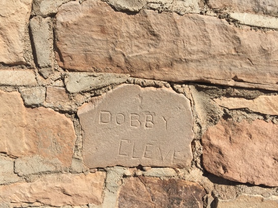
Brick from the wall at the Civilian Conservation Corps in Leeds, Utah. Photo by Bill Deverell.

By Bill Deverell

After a great Fourth of July in St. George, my son and I headed out this morning to Colorado. First stop was the CCC camp in Leeds, just east of St. George. Here’s a photo I took of the wall of the CCC officer’s quarters up on the hill. It’s likely, given the other signatures I saw, that this was not “Dobby Cleve.” I think it may have been a man named Dobby who was from Cleveland. What’s amazing about our ability to do family history these days, through various genealogy sites, is that a couple of hours of work would probably allow us to find out just who this was, this man who scratched his name into the stone of a small building in the red sandstone hills of southwestern Utah in the heart of the Great Depression.

Up and out of the canyons surrounding St. George and on towards Cedar City. Here, where there is now a superb Shakespeare Festival, is the site of one of the most notorious massacres in all of American history. In 1857, at the height of tensions between the Mormon theocratic community and the federal government (which resulted in the Mormon War), the Baker-Fanchon wagon train bound for the far West wandered through nearby Mountain Meadows. The emigrants hailed mostly from Arkansas, though they had absorbed some others from Missouri. These later additions may have heightened the tensions, seeing as they came from a region which had so recently persecuted the Mormons in one violent encounter after another.

Mormon militia members, in league with local Paiute Indians, attacked and put the wagon train under siege. After several days, Mormon fighters approached the train under a white flag, offering the emigrants protection and safe escort back to Cedar City. It was a ruse. Once on the trail, the Mormon militia members turned their weapons on the settlers. With the exception of the very young, all were murdered, well over 100 people. Adding another macabre note, the spared children were brought back to Mormon families to be raised as adoptees (some later returned to Arkansas by federal officials). To top off the weird grimness of it all, the one man brought to justice for the massacre, John D. Lee, was executed by federal firing squad twenty years later, sitting on the edge of a coffin at the very site of the massacre. I can’t drive by Cedar City without thinking of all this.

We usually press on to Salt Lake when we take this trip each summer. But this year, a deviation. We turn east onto I-70, bound for Colorado to visit my family. This is a glorious detour from our regular route. Such stunning canyon country, and if you look closely, the landscape reveals far more color than just the spectacular sandstone red. Reds in rich array, whites, grays. It is breathtaking. Not many people live out here, but here and there you can see an old cabin. And in the valleys, where there’s at least a little water, small communities.

On the way into Grand Junction, Colorado, we drove alongside and over the Green River. Full of snowmelt as we saw it today, lazy and powerful, the Green is the parent of the mighty Colorado, falling out of the Wind River Range in Wyoming, where we will be in a week or so.

Tomorrow, we hunker alongside the Colorado River for awhile, a route I love, a trip also alongside the history of the Rocky Mountain West, a journey from the western slope up and over the Rockies to the front range.